February 2016 Website

Hampshire County Council, Winchester City Council, the Environment Agency, and the University of Southampton worked together to develop a flood water management scheme around the North Walls/Park Avenue area of the city which created flood defences to protect properties and assets to the north of Winchester city centre against fluvial (river) flooding from the River Itchen and to reduce resources required during future flood events.
The River Itchen flows from its source, south of Cheriton, through the City of Winchester to Southampton Water. The Itchen’s flow is restricted through Winchester by the Durngate Sluice, City Mill and Wharf Mill.
The River Itchen is a chalk stream and is fed by groundwater. During prolonged periods of rainfall the ground water levels rise resulting in an increase in the water level of the river.
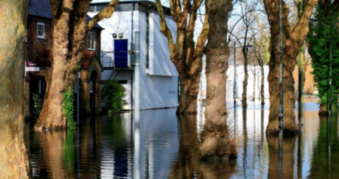
Historically, the River Itchen flooded in 1852, 1903, 1928, 1935, 1947, 2001 and 2014. The greatest impact occurred in the winter of 2000/2001, with significant damage to properties and assets within Winchester. The highest level of flood water was recorded in 2014.
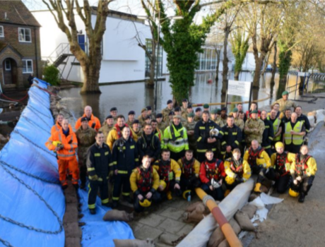
The most recent flooding occurred in the winter of 2013/2014 where a well-managed flood response from Hampshire County Council, Winchester City Council and the Environment Agency prevented significant damage to properties and assets from occurring. The response involved a great deal of intensive work and associated resources provided through joint agency working and with government support.
A hydraulic modelling assessment was undertaken to determine the river flood water level associated with the 1% annual probability flood (1:100 year storm return period), plus 30% increase to allow for climate change. All new flood defences were constructed to the height of the 1% annual probability flood +30% climate change water level, this is greater than the highest water level recorded during the 2014 event.
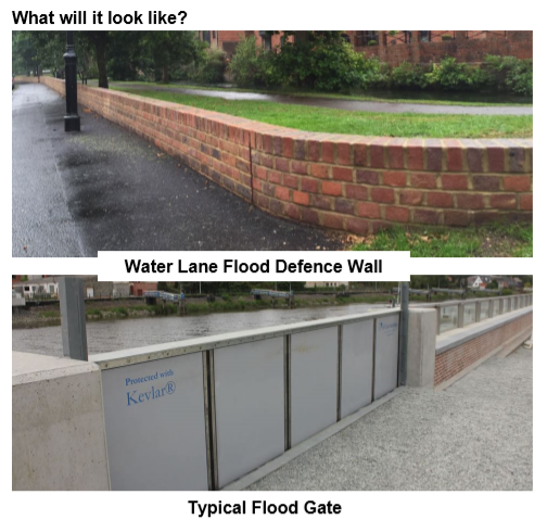
The flood defences mainly consist of brick walls which reduce the need for temporary sand bags to be installed during a flood event. Where gaps in the wall are required, they can be closed during a flood event using temporary flood gates, or sand bags as part of the Multi Agency Flood Action Plan.
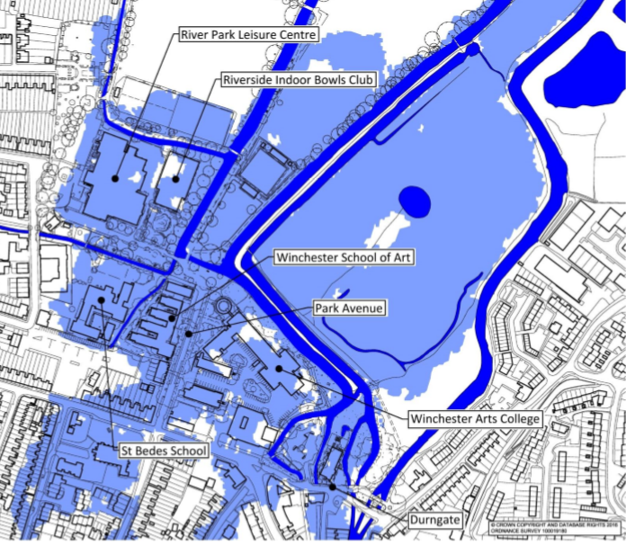
Hydraulic modelling was carried out to produce a map that identified the areas within the north of Winchester that are at risk of fluvial flooding during a 1% annual probability flood, including an increase of 30% to allow for climate change. The depth of the flood water can be up to 600mm, dependent on location.
Does this mean Winchester is protected against flooding for the next 100 years?
‘No, a return period is a magnitude of storm, not an interval between flood events. It does not mean that a 100-year flood will happen regularly every 100 years, or only once in 100 years. In any given 100-year period, a 100-year event may occur once, twice, more, or not at all.’
Will this stop my house from ever flooding?
‘No, if your property is shown to be within the defended area in figure 2 then once the scheme has been implemented it will be protected against the 1:100 year plus 30% storm event, as long as the defences remain in place and the standard of protection is not exceeded.’
How do I protect my property if the design storm is exceeded?
‘Property level protection should be considered such as flood gates, air brick covers and sand bags, visit https://www.gov.uk/prepare-for-a-flood for more information. Also register your property for flood warning updates at https://fwd.environment-agency.gov.uk/app/olr/register.’
Why can’t the wall be built higher to give greater protection?
The top of the wall has been designed to be 100mm above the 1% annual probability flood event (including a 30% increase to take account of climate change) to provide a safety factor. There is also a limited budget for the scheme and a higher wall may not be considered to be acceptable aesthetically, consequently this level of protection was deemed appropriate.’
What will be done if it looks like the water level is rising to over top the wall?
‘The type of flooding that occurs north of Winchester is a build-up of water caused by extended periods of prolonged rainfall. This raises both river levels and the levels of the groundwater, but is a slow process and it is not a ‘flash’ flood similar to those that have occurred recently elsewhere in the country. This slow onset allows additional defences i.e. sand bags and temporary barriers to be installed should the wall be at risk of being overtopped.’
How do you know it will work?
‘The wall has been designed following detailed flood water modelling of the surrounding areas and designed using best practice engineering.’
What has been done since the 2014 flooding?
‘Careful sluice management in the 2014 floods was a major factor in reducing the impacts of flooding in the city. Since the floods the various organisations and bodies responsible for sluice management and maintenance in the city have formed a Sluice Management Group to ensure that this good work will be repeated in the future. Work has also been carried out by the Environment Agency to replace sluices to enable better flow management.
The Multi Agency Flood Action for Winchester has been updated to take account of the lessons learnt during the 2014 floods.
A flood defence wall has been constructed within Water Lane to protect against the 1% annual probability flood, including an increase of 30% to account for climate change.’
A flood-protection scheme costing a million pounds has been revealed in Winchester.
https://www.heart.co.uk/southcoast/news/local/1m-winchester-flood-wall-unveiled/ 23 August 2017
Storms in 2001 and also in 2014 left the St Bede’s and River Park areas underwater. A new wall’s been built which has barriers that can be slotted in when they’re needed.

In the partnership jointly funded by Hampshire County Council (£290,000), Winchester City Council (£144,000), the Environment Agency (£591,000) and University of Southampton (£60,000), a new low wall has been installed featuring openings for everyday access, which can be closed when needed by slotting in flood gates, to protect the St Bede’s and River Park areas of the city including St Bede School, Winchester School of Art, homes and businesses.
“This flood barrier provides much needed relief and peace of mind for residents in the St Bede’s and River Park areas, which were badly flooded in 2000/01 and 2013/14 following prolonged periods of heavy rainfall. Flooding is a shared problem which is why a shared solution was needed. I’m grateful that Winchester City Council, the Environment Agency and the University of Southampton have worked with us to build this flood defence to help protect the local community in this part of the city.”
Councillor Roy Perry, Leader of Hampshire County Council,
Councillor Jan Warwick, Winchester City Council’s Portfolio Holder for Transport & Engineering said:
“We all recall how disruptive the floods were in 2013/14. These measures should help to reduce the risk of flooding and will hopefully provide reassurance in terms of preventing the damage floodwater causes to private and public property. The scheme is a good example of different parties coming together in order to find a way to tackle the problem of flooding, and shows our collective commitment to investing in the future of Winchester.”
Wesley Jones, Flood Team Leader (Hants and IoW) at the Environment Agency, said:
“This partnership scheme has combined central and local government funding to quickly and efficiently deliver a reduced risk of flooding to nearby properties. This work complements the Environment Agency’s recent construction of the natural flood storage areas upstream, so that Winchester is now in a much better position to manage flooding in the future.”
The University of Southampton’s Director of Estates and Facilities, Kevin Monaghan said:
“Winchester School of Art is an important institution in the city, attracting investment and jobs as well as the creative young people who help make Winchester such a vibrant city. In the past, severe flooding has caused significant disruption to our Winchester School of Art campus and the new flood defences are most welcome. We were pleased to work collaboratively with Winchester City Council, Hampshire County Council and the Environment Agency to find a long-term solution that protects us and also our neighbours.”
The wall has been built in red brick along North Walls/Park Avenue to match existing municipal walls in the area, and blend into the street scene – similar to the recently constructed flood defence wall in Water Lane.
However, the core and foundation of the new wall is reinforced concrete – capable of resisting the calculated water pressures.
The scheme received positive feedback during a public consultation in 2015. Minor concerns about the removal of trees have been addressed, with eight new trees and shrubs planted around the nearby River Park Leisure Centre, as well as new shrub planting within the play park.
A second phase of the defences, to be funded by Winchester City Council and the Environment Agency, is currently being designed by Hampshire County Council. This scheme will look to add additional flood protection to areas south of the Durngate Bridge, with works likely to commence in spring 2018.
Work starts on Winchester flood defence scheme
https://www.winchester.gov.uk/news/2020/jun/work-starts-on-winchester-flood-defence-scheme June 2020
Construction on a major new flood defence for Winchester at Durngate has started.
The scheme will provide three new sluice gates on the remaining uncontrolled channels of River Itchen to help to protect the city centre, homes and businesses from high water levels. It will complete the city’s network of defences across the north of the city to help to control flooding, including the historic City Mill.
The sluice gates are adjustable so they can help to manage the flow of river water – the gates will be able to hold back up to 250,000m3 of water, equivalent to around 3.2 million bathtubs of water. Work is now underway on a temporary dam to enable the installation of the first sluice gate. Two of the gates will be located either side of Durngate car park with the third between the road and pedestrian bridge at the entrance to Winnall Moors – once in place earthworks will link the defences all together from the School of Art to the main river.
The £1.6m scheme is funded by Winchester City Council with £548k provided by the Environment Agency, part of a six-year programme worth £2.6bn to protect 300,000 homes across England.